Maya Archaeological Sites of Belize
Cayo District
 Caracol Mayan Archaeological Site. Caracol's ancient Mayan name was Uxwitza, or "Three Water Hill." Its Early Classic name was Ux Witz Ajaw, or "Three Hills Lord."
A.H. Anderson, Archaeological Commissioner for Belize in 1938, named the ruins Caracol, meaning "snail" in Spanish, because of the the winding roads leading to the site. (Anderson first visited the site in 1937 after it was discovered by logger Rosa Mai in 1937.)
Caracol is the largest partially excavated Maya site in Belize covering about 75 square miles (larger than modern day Belize City). At its peak (approx. 650 AD), Caracol's epicenter, or town, housed about 15,000 people, with 120,000 - 180,000 living in the Caracol "suburbs" - settlements along the paved causeways radiating from the epicenter of Caracol.
Caracol was first occupied around 1200 BC, but its epicenter was not populated until around 650 BC, and was abandoned in approximately 950 AD, with the entire site abandoned by 1050 AD.
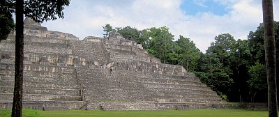
Caana (meaning sky palace), the main pyramid at Caracol, houses 4 palaces and 3 temples and remains the tallest building in modern Belize, with a height of approximately 141 feet. Along with Caana, structures at Caracol include 24 known stelae, 24 alters, a ball court, reservoirs, causeways, 5 plazas, an astronomic observatory, central acropolis, two ball courts, over 35,000 known buildings and more than 100 tombs. However, little of Caracol has been excavated except its central core, including 3 plaza groups, the acropolis, the two ball courts, Caana, several smaller structures and a visitors center.
In 2009, aerial laser mapping of Caracol allowed archaeologists to literally "see" through the jungle growth to produce a 3-D map of Caracol, and to reveal many parts of Caracol that had not yet been discovered, especially paved causeways and agricultural terraces that fed Caracol's large population. (See New York Times article for more information.)
Caracol was probably originally a client state of Tikal However, through urban planning and calculated warfare, Caracol became one of the most important city states of the Classic Period in the Maya Lowland region. (Caracol defeated both Tikal and Naranjo in major wars and the architecture of Tikal mimics that of Caracol after Tikal's defeat by Caracol.)
Evidence also indicates that Caracol survived the initial collapse of the Maya civilization.
Caracol is located in the foothills of the Maya Mountains about 25 miles south of Xunantunich in Belize's Cayo District.
Latitude: 16°45'50.40"N/Longitude: 89° 7'8.76