Placencia Cayes and Reef
(Information from the Belize Coastal Zone Management Authority and Institute)
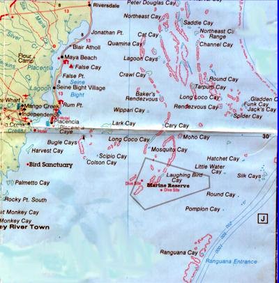 Approximately 75 cayes are in the Placencia/Laughing Bird Caye Coastal Planning Region (from the mouth of the South Stann Creek River to the Mouth of Monkey River, extending seaward to include the Meso-American Barrier Reef, with Norval Caye in the north, Pompion Caye in the south, and Gladden Spit in the east).
Cayes range in size from about 65 acres (Lark Caye) to only several square yards. The great majority of cayes are subject to some form of ownership claim (either ownership or lease), either wholly or partly.
The region, occupying part of the southern reef complex, extends at its greatest width (between Placencia Caye and Gladden Spit) for about 25 miles, and taking the Barrier Reef as the eastern limit, covers an estimated 90,400 acres of sea and cayes. The region can be viewed as having three sections:
- The "Barrier Reef Cayes" -- characterized by cayes such as Gladden, Buttonwood, Hatchet, Little Water, Pompion and the Silk Cayes
- The "Inner Reef Cayes" -- including the Pelican Cayes, Quamino, Tarpon, Bakers Rendezvous, Lark, Moho and Laughing Bird Cayes
- The "Shoreline Cayes" -- cayes such as False, Placencia, Palmetto, Rocky Point and Great Monkey
The Barrier Reef extends from the north to Gladden Spit south where it becomes fragmented with large outcrops around the Silk Cayes diminishing in size further south. The Gladden and Queen entrances give access to and from the deep sea, though neither have greater depth than about 8 meters, insufficient for ocean-going shipping, particularly as the bathymetry becomes complex around the cayes with numerous coral heads and shoals. Depths on the main part of the Barrier Reef platform average 3 to 5 meters, giving most of the cayes in this region shallow access. Most of the cayes lying to the north of the Gladden Entrance are low-lying mangrove cayes, while those lying to the south are high coral sand cayes. The cayes lying along the Barrier Reef south of the entrance have been subject to substantial morphological change over the years, mainly due to the effects of hurricanes. This is not so true of other cayes in the region.
The Victoria Channel, with depths of 30 to 44 meters, separates the Barrier Reef Cayes from the Inner Reef Cayes. The Channel, in essence a large lagoon, connects to the Inner Channel in the vicinity of Crawl Caye, and extends fingers north around the Pelican Cayes and south towards another similar "lagoon" west of Ranguana Caye. The channel also gives deep-water frontage to several of the "Inner Cayes" on the windward side, such as Elbow, Channel, Crawl, Bakers Rendezvous, Long Coco, Mosquito, Moho and Laughing Bird cayes. Some of these cayes are high and sandy, others low and dominated by mangrove, yet there appears to be no discernible pattern determining this. More research is required on offshore currents and sediment transport.
The Inner Reef Cayes can be split into two parts (1) a northern group (e.g., the Pelican, Elbow, Norval, Quamino, Channel, Tarpon and Lagoon cayes) laying north of the Victoria Channel/Inner Channel connection on clearly defined reefs and faros; and (2) a southern group (e.g., Crawl, Lark, West Long Coco, Bugle, Moho, Laughing Bird cayes) lying in a complex of shoals, reefs, coral heads and channels, and directly east of Placencia and Monkey River. This underwater complex continues south, though no more cayes appear until the Sapodilla and Snake cayes.
The Inner Channel, the main commercial shipping route, follows the coastline running from the north (where it connects to Commerce Bight pier and eventually to Belize City) to Big Creek Port and then further south towards Puerto Barrios in Guatemala, though the channel loses much of its depth south of Big Creek.
The Shoreline Cayes are more isolated and extend almost evenly down the coast, often less than a mile offshore. The majority of these cayes are low though it is noticeable that Palmetto, Harvest and Rocky Point form a type of barrier between the Sea and the mainland and consequently can be quite high on the seaward (east) side.
There are few obvious indicators of sea level rise; indeed local reports claim that several sand bars and shoals have become more pronounced in recent years. However, this could be related more to the influence of hurricanes, which appear to be the main determining factor in alterations to the physical characteristics of the cayes though, as mentioned above, this seems to be focused mainly on the Barrier Reef Cayes. Considerable erosion is reported on the mainland, along the Placencia Peninsula (which could be at least partially caused by alteration and development of the shoreline).
The predominate off-shore current is, as with most of the Belizean coast, north to south, fed by sediments mainly from North Stann Creek, Sittee River, South Stann Creek, and Mango Creek /Big Creek. Monkey River generally flows to the south, though its plume can occasionally turn slightly northward. However, it does not appear that granite and/or metasedimentary sediment carried to the coast by the North Stann Creek or even the Sittee and South Stann Creek has had any great effect in building up any of the cayes; nearly all the sand on the cayes is carbonate sand.
The seabed in this region, as with the cayes, can be divided into three sections; the "Barrier Reef Platform," the "Inner Reef Complex" and the "Coastal Strip."
The Barrier Reef Platform extends for almost 5 miles at its greatest width north of Gladden Spit and has average depths of 1 to 8 meters. It narrows to about 4 miles in the vicinity of Pompion Caye, south of which it narrows further. The reef around Gladden Spit is noted for its wealth of marine life including a fine range of corals. The Barrier Reef stretches continuously from the north to Gladden Spit, with only occasional breaks, such as the South Cut at the northern limit of the planning region. South of the spit the formation breaks up into intermittent clumps, several of them covering up to 20 acres, until it masses again towards the Sapodillas.
The Inner Reef Complex has been described as consisting of a "maze of patch reef, faros, and pinnacles" (Perkins). Some faros, such as around the Pelican Cayes, can average around 2 to 3 meters in depth. This maze is intersected by deep water channels averaging 25 to 45 meters which can rise rapidly up to reefs around such cayes as Crawl, Moho and Laughing Bird. In fact, the reef running from Crawl to Baker's Rendezvous has been described as the most extensive surface-breaking reef of the Inner Cayes (Rauscher, 1996). Several of the cayes in this area also have lagoons of considerable depth, mostly surrounded by reef.
The Coastal Strip, composed mostly of sediments, has depths in the northern part of the region to about 24 meters, though it becomes more complex south of Placencia Caye with several shoals and a maximum depth of 17 meters. At its greatest width, roughly from Seine Bight to the Crawl Caye reef, it extends for 8.5 miles, narrowing to about 2.5 miles between Placencia Caye and Bugle Cayes.
Numerous cayes are noted as bird nesting sites, particularly for pelicans and frigates, although some osprey nesting sites have also been reported. Egrets have been noted on several of the near shore cayes. One or two cayes in the region are reported as once being popular seasonal nesting sites for swallows, though this appears to have declined in recent years.
Hawksbills turtles have been reported as having nesting grounds on Long Coco (East), Rendezvous, the Silk Cayes, Laughing Bird, Pelican (Cat) Northeast and Pompion. Loggerhead turtle nesting grounds are reported on Rendezvous, Silk and Round (South) cayes. Leatherback turtles were spotted swimming east of the Pelican (Cat) South cayes. Manatees have been sighted around the Pelican Cayes and the Lark Range, though the greatest concentration is in and around the mainland lagoons (e.g., Placencia and Indian Hill Lagoons).