 Xunantunich Mayan Archaeological Site. The Xunantunich core is about 1 square mile and includes 6 plazas and 26 temples and palaces.
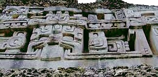
El Castillo, a 130 foot tall pyramid at the axis of the core of Xunantunich is the second tallest building in Belize after Caana at Caracol.
Although the core of Xunantunich is fairly small, the city was surrounded by a much larger farming community, including economically self sufficient villages that did not have to rely on Xunantunich for food or supplies. Archaeologists believe that these self-reliant villages in large part allowed Xunantunich to survive almost 100 years past the time when most other city states in the Maya Lowlands were collapsing.
Large monumental construction started in Xunantunich in 600-670 AD and thrived until 750 AD when Xunantunich was abandoned due to an "unknown violent event." The city did not start to regain its strength until 780-890 AD, when it eventually replaced Naranjo as a regional power. (Naranjo had been a major Maya city state along with Tikal and Caracol. However, Naranjo began to decline at around 820 AD, the same date as the earliest dated stela at Xunantunich, and the hieroglyphs and architecture of Naranjo and Xunantunich are very smilar, including architectural layout of the two cities.)
The ancient name of Xunantunich is not known. Xunantunich means "Stone Woman" in Mopan and Yuatec Mayan and refers to the ghost of a woman many claim to have seen at Xunantunich since the 1890s. The woman is always dressed in white, has fiery red eyes and appears in front of El Castillo where she climbs the stairs and disappears into the stones.
Xunantunich is located just outside San Ignacio in the Cayo District of Belize.
Latitude: 17° 5'2.04"N/Longitude: 17.0839° N, 89.1339° W